On 15th February, there was a news report on how Uttarakhand has finally struck an agreement on the Lakhwar and Kishau Dams with its neighbouring state Himachal and other states vying for the water share from these projects which were part of the Yamuna inter state agreement signed in the 1990s. “The Yamuna Review Committee meeting chaired by Union Minister for Water Resources Nitin Gadkari in New Delhi today in which CMs of neighbouring states were present, Uttarakhand Chief Minister TS Rawat forcefully put across the state’s case”, the report said.
Be it Renuka or Kishau Dam, they seem to be the same old ‘clogged’ pipe dreams. There may be multiple reasons for the delays in these projects, which there is a general agreed silence on’ – the slump in hydro sector or the absence of funding, the sorry state of dams in the country in general, the conflict over water sharing across states. But this is not the only common thread binding these projects. The extent and nature of displacement and environmental threats are also more or less the same across some of these projects on the Yamuna basin, which were all planned under the Upper Yamuna Basin Agreement signed by 5 states in the 1990s.
In 2014-15, Prakash Bhandari and Kesang Thakur of Himdhara Collective, carried out a field investigation and study of the area to be impacted by the proposed Kishau Dam in Himachal and Uttarakhand. This report “Submerging Jaunsar Bawar” puts together the findings of the study. According to information provided under RTI by UJVNL, 9 villages from Uttarakhand and 8 villages (6 from Sirmour and 2 from Shimla district) are going to be affected by Kishau dam project and it’s submergence area will spread over 2950 hectares. Of the total submergence area, 512 hectares is cultivated private land and 2438 hectare is forest land. A total of 5498 people belonging 701 families will be directly affected by the project.
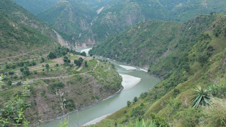
The project involves building of a 236 m high dam on river Tons, which is a major tributary of the Yamuna, originating in the Jamnotri mountains and passing through Shimla and Sirmour districts and Jaunsar Bawar region in district Dehradun. Except in some parts, where it flows through the small town of Tiuni and a little beyond, the river forms boundary of the states of Uttarakhand and Himachal Pradesh. It enters Sirmour district of Himachal near village Kot and forms the eastern boundary of the district for about 50kms before it joins Yamuna near Khodar Majri. The submergence area on the left bank is part of Jaunsar Bawar region of Chakrauta tehsil, district Dehradun which is a Schedule-V area. A major part of the submergence area on the right bank will be in Sirmour and Shimla districts of Himachal and a smaller portion in Uttarakhand after Faedij bridge on Dehradun-Tiuni road. Part of Himachal going to be affected by Kishau dam is similar to the left bank but is not a declared Schedule-V area. The area is inhabited by Jaunasari and Bawar tribe who believe that they are descendants of Kauravs and Pandavas.
All along 44.5 kms of the submergence area, villages are located on both sides of the river at some interval. The villages on the right bank in Sirmour district are connected via rope trolleys to Tiyuni- Dehradun road. There are strong religious, cultural and economic ties between villages on both sides.
Agriculture with livestock rearing is the main livelihood activity in the region. Farming is carried out in relatively flat lands with irrigation facilities available all round the year thus allowing multi cropping and highly productive farming. People also practice commercial farming and cultivate crops like ginger, turmeric, cabbage, tomatoes and ground nut etc on a large scale. The forest based livelihood and food system will be completely destroyed as more than 15 lakh trees will face the axe because of this project.
If we look at the cost-benefit analysis only from the point of view of the state of Himachal Pradesh, the ratio seems quite poor. Himachal will get no share in the irrigation, only 50% in the power and will lose 177 hectares of cultivated land, 1321 hectares of forest land and will displace hundreds of families in return. Evidently, the priority of the Himachal government remains distorted – with the focus on earning higher revenues instead of looking at the concerns of its own people and environment. This is clear from the fact that for signing the MoU with Uttarakhand, Himachal government has been demanding a higher share in the additional power going to be generated in the hydropower projects downstream of Kishau Dam.
 However, state boundaries hold little meaning when we take a birds eye view. The cumulative geological impacts of three huge impoundments – Tehri, Kishau and Renuka Dam in almost parallel valleys of a Himalayan region – adjacent to one another are not even being considered.
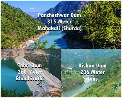
If Kishau and the proposed 315 metre Pancheshwar dams are built then one of India’s most disaster prone states, Uttarakhand, will also be the site of the three highest dams of the country (Pancheshwar (315m), Tehri (281m) and Kishau (236m)).
See the report here Kishau Report FINAL


